
In 2016, the Ohio Department of Transportation (ODOT) initiated the Ohio Moves Transportation Study, using rMove® to gather travel data from residents statewide. Building on ODOT’s prior GPS subsampling experience, this initiative was the first in the nation to employ a seven-day, smartphone-based GPS survey to understand statewide travel behavior among residents.
The survey provides essential data, enabling Ohio to refine its travel models, transportation planning, and infrastructure strategies. Conducted annually, it allows ODOT to quickly adapt to Ohioans’ evolving transportation needs. A related effort, the Ohio Moves Long-Distance Study, focuses on gathering data for trips over 50 miles to help practitioners understand when, why, and how residents in the state make longer trips that fall outside of their daily routines.
The Ohio Moves Transportation Study’s data collection is vital for updating Ohio’s travel demand models. It offers a methodologically and empirically sound basis for evaluating the state’s transportation system and planning for residents’ needs. This approach underscores ODOT’s commitment to fostering a transportation network that sustainably supports Ohio’s growth.
The Challenge
For decades, travel behavior researchers hypothesized that paper diary or web- and telephone-based recall surveys deliver an incomplete picture of travel behaviors. Before smartphones, GPS loggers (separate devices participants carried) were seen as a potential alternative to paper, web, or telephone surveys. In 1997, a “proof-of-concept” project led by the Federal Highway Administration in Lexington, Kentucky, demonstrated both the feasibility of GPS data collection and confirmed the existence of the missing (mostly shorter) trips hypothesized by researchers.
When the Ohio Moves Transportation Study began in 2016, the use of GPS logger-based subsamples was the primary method used to assess and correct for trip under-reporting. To help ODOT overcome the known limitations of traditional methods, which often rely on self-reported data, researchers proposed a smartphone-first methodology. However, this approach would require navigating issues around data privacy, smartphone uptake and use, and integration with other methods.
Moreover, Ohio’s geographic diversity, from urban centers to rural areas, necessitated a versatile and comprehensive travel survey methodology and outreach approach. Ensuring widespread participation and addressing stakeholder concerns were essential to the project’s success. As innovators in data collection and location-aware market research technologies, ODOT, in collaboration with RSG, proposed using rMove to gather accurate and comprehensive travel data from residents across the state.
RSG’s Solution
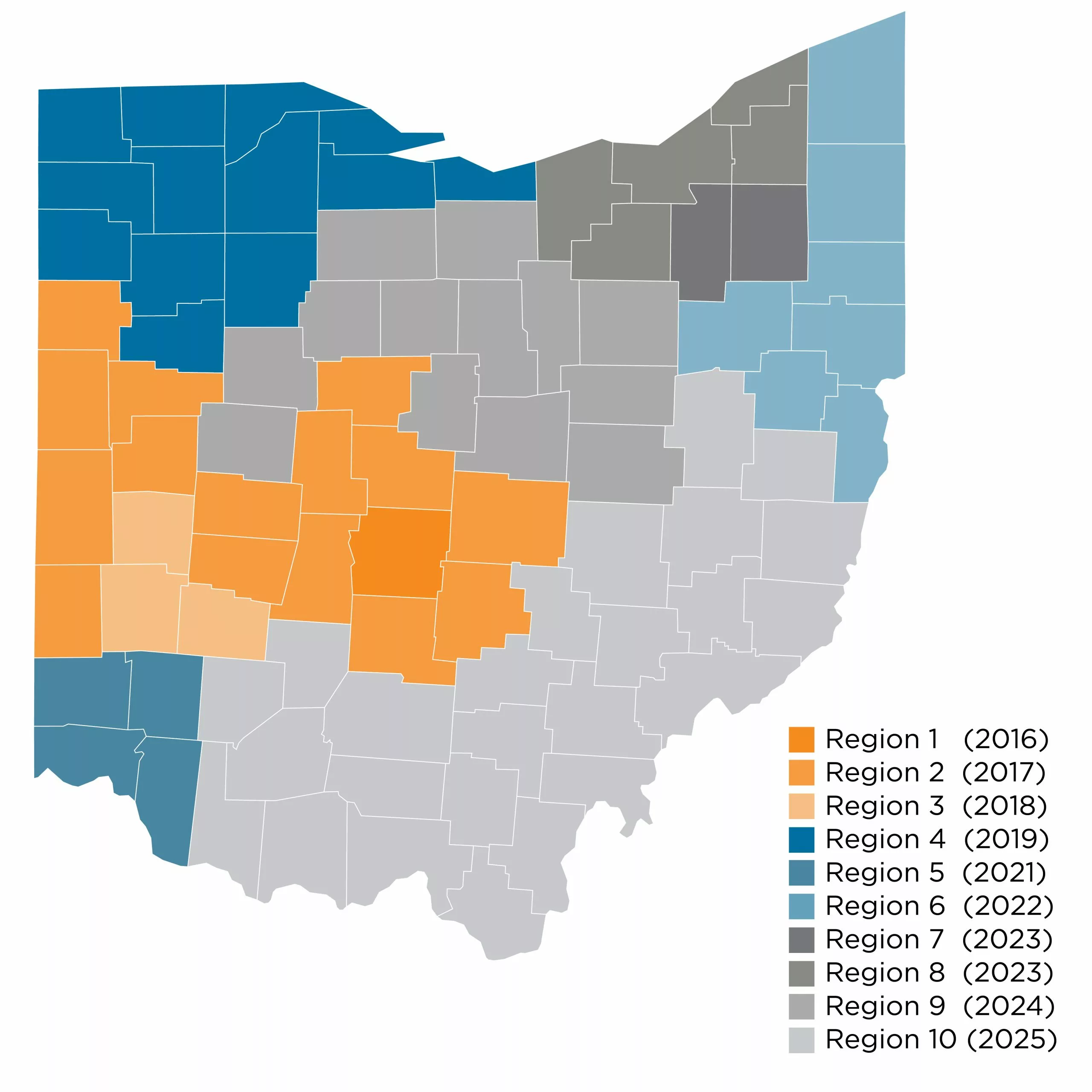
For the Ohio Moves Transportation Study, ODOT segmented the state into 10 regions. Using this method, one region is surveyed each year using a region-specific sampling plan, collecting data from approximately 2,300 households, or around 0.5% of households in each region. Each household receives an invitation to participate using rMove. Researchers weight and expand these data to represent the entire region. This approach puts ODOT on a decennial cycle to collecting and combining travel survey data for the entire state. ODOT administers these surveys between September and April, with a short pause in data collection between December and January to account for periods of anomalous travel around the holidays. A long-distance survey, the Ohio Moves Long-Distance Study, is a separate six-month study that most households also participate in to collect data on trips over 50 miles.
Initially, from 2016 to 2018, loaner phones were provided to bridge the technology gap for participants without smartphones who wanted to use rMove. However, a significant increase in smartphone adoption among the survey population, combined with the availability of complementary survey methods, enabled the design to shift away from using loaner phones. Despite this change, between 2018 and 2023, more than three-quarters (77%) of survey respondents, on average, have opted to participate using their smartphones.
The Ohio Moves Transportation Study has significantly enhanced the state-of-the-practice around data collection and modeling in Ohio. Annual data collection using rMove has helped ODOT become more responsive to residents’ transportation needs. Despite a brief pause in fieldwork during the first year of the pandemic, ODOT has collected data every year since 2016. Beyond the immediate logistical achievements, the study has created the empirical foundation for Ohio’s transportation planning and modeling needs, enabling the state to forecast residents’ changing travel needs effectively. This strategic approach has helped with planning for a transportation network that not only meets the current demands but that supports Ohio’s growth and changing population.


